
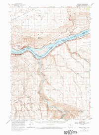
1957 Map of Wishram
USGS Topo · Published 1959About this map
The Columbia River forms a massive corridor through this mid-century landscape, separating the high plateaus of Klickitat Valley in Washington from the deep canyons of Oregon. At this time, the river's flow is defined by Celilo Lake, while the banks are busy with the competing paths of the Spokane Portland and Seattle and Union Pacific railroads. On the northern shore, the Stonehenge Memorial and Maryhill Museum stand as distinct landmarks atop the Columbia Hills, while the community of Wishram serves as a vital rail hub. To the south, the Deschutes River carves a sharp path toward its confluence, flanked by rural settlements such as Kloan and Harris. Evidence of upland agriculture and early education appears at the Douglas Hollow School, showing the persistence of homesteading life in the dry breaks of the Gordon Ridge and Fulton Canyon country.
Find a feature on this map
65 named features on this map. Tap any name to fly to it.
Don’t see what you’re looking for? This feature index may not catch every label — zoom into the map to look around manually.
Map Details
Editions of this 1957 Wishram Map
2 editions found
Other maps of this area

1930 · Dufur
USGS Topo · 1:125,000

1934 · Dufur
USGS Topo · 1:125,000

1934 · The Dalles
USGS Topo · 1:125,000

1953 · The Dalles
USGS Topo · 1:250,000

1956 · The Dalles
USGS Topo · 1:250,000

1957 · The Dalles
USGS Topo · 1:250,000

1957 · Wasco
USGS Topo · 1:62,500

1957 · Klickitat
USGS Topo · 1:62,500

1957 · Goldendale
USGS Topo · 1:62,500

1957 · The Dalles
USGS Topo · 1:62,500