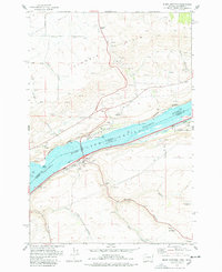
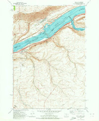
1977 Map of Biggs Junction
USGS Topo · Published 1978About this map
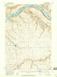
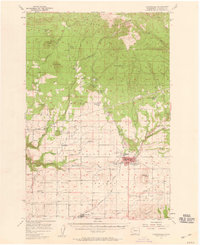
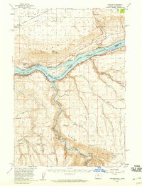
Lake Celilo and the Columbia River dominate this 1970s landscape at the border of Washington and Oregon, marking a point where heavy transport and regional history intersect. On the northern shore, the community of Maryhill is home to the Maryhill Museum and the notable Stonehenge Memorial, a concrete replica situated near the Columbia Hills. South across the Sam Hill Memorial Bridge, the transportation hub of Biggs Junction serves as a nexus for the Union Pacific and Burlington Northern railroads. The map records the industrial and agricultural infrastructure of the era, from the Grain Elevator and various Borrow Pits near Biggs to the small settlement of Thornberry nestled near Spanish Hollow. The presence of several Cemeteries and family-named terrain features like Frank Fulton Canyon and Hartley Canyon provide specific points of interest for genealogical research into the families of Klickitat and Sherman counties.
Find a feature on this map
37 named features on this map. Tap any name to fly to it.
Don’t see what you’re looking for? This feature index may not catch every label — zoom into the map to look around manually.
Map Details
Editions of this 1977 Biggs Junction Map
This is the sole edition of this map. No revisions or reprints were ever made.
Other maps of this area

1953 · The Dalles
USGS Topo · 1:250,000

1956 · The Dalles
USGS Topo · 1:250,000

1957 · The Dalles
USGS Topo · 1:250,000
1957 · Wasco
USGS Topo · 1:62,500
1957 · Goldendale
USGS Topo · 1:62,500
1957 · Wishram
USGS Topo · 1:62,500
1957 · Satus Pass
USGS Topo · 1:62,500
1971 · Rufus
USGS Topo · 1:24,000
1971 · Wasco
USGS Topo · 1:24,000
1974 · Locust Grove
USGS Topo · 1:24,000