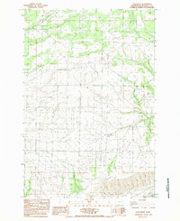
1983 Map of Luna Butte
USGS Topo · Published 1983About this map
The Little Klickitat River cuts across the northern reaches of this landscape, a remote section of South Central Washington defined by the transition from the Klickitat Valley toward the dramatic rise of the Columbia Hills. This 1983 survey captures the area just as Lake Umatilla had become a permanent fixture of the southern boundary along the Columbia River. The map documents a sparsely populated terrain where water sources like Harper Spring and the drainage of Swale Creek were critical to the local geography. Significant topographic landmarks include Luna Butte and the adjacent Luna Gulch, which provide vertical contrast to the broad basin of the valley. A major utility Pipeline is shown traversing the southern hills, reflecting the infrastructure development connecting the Columbia River corridor to the interior highlands during the late twentieth century.
Find a feature on this map
9 named features on this map. Tap any name to fly to it.
Don’t see what you’re looking for? This feature index may not catch every label — zoom into the map to look around manually.
Map Details
Editions of this 1983 Luna Butte Map
This is the sole edition of this map. No revisions or reprints were ever made.
Other maps of this area

1953 · The Dalles
USGS Topo · 1:250,000

1956 · The Dalles
USGS Topo · 1:250,000

1957 · The Dalles
USGS Topo · 1:250,000

1957 · Wasco
USGS Topo · 1:62,500

1957 · Goldendale
USGS Topo · 1:62,500

1957 · Wishram
USGS Topo · 1:62,500

1957 · Satus Pass
USGS Topo · 1:62,500

1971 · Quinton
USGS Topo · 1:24,000

1971 · Rufus
USGS Topo · 1:24,000
1977 · Biggs Junction
USGS Topo · 1:24,000