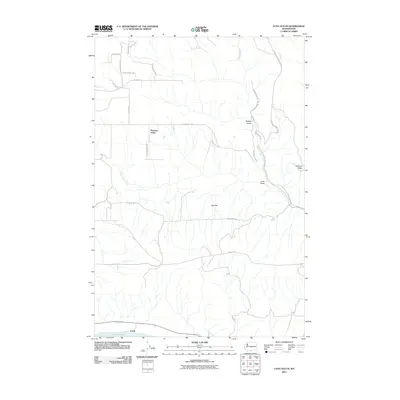
2011 Map of Luna Gulch
USGS Topo · Published 2011About this map
Pleasant Valley sits at the heart of this high-plateau landscape in southern Washington, where the terrain is defined by deep drainage systems carving toward the Columbia River. The map shows a transition from the elevated plains of Oak Flat and Harrison Ridge down into the rugged incisions of Badger Gulch and Luna Gulch. The southern edge of the sheet is dominated by the shoreline of Lake Umatilla, part of the Columbia River system, near the small settlement of Towal. Insight into the area's development is visible through its road network, where legacy routes like the Goldendale Bickleton Rd and Bickleton Hwy cross the drainage of Rock Creek. Local family names and geography are preserved in labels for smaller arteries such as Bill Anderson Rd and Hoctor Rd, reflecting the rural agricultural and ranching history of Klickitat County.
Find a feature on this map
25 named features on this map. Tap any name to fly to it.
Don’t see what you’re looking for? This feature index may not catch every label — zoom into the map to look around manually.
Map Details
Editions of this 2011 Luna Gulch Map
This is the sole edition of this map. No revisions or reprints were ever made.
Other maps of this area

1916 · Arlington
USGS Topo · 1:125,000

1953 · The Dalles
USGS Topo · 1:250,000

1956 · The Dalles
USGS Topo · 1:250,000

1957 · The Dalles
USGS Topo · 1:250,000

1957 · Wasco
USGS Topo · 1:62,500

1957 · Satus Pass
USGS Topo · 1:62,500

1965 · Goodnoe Hills
USGS Topo · 1:24,000
1965 · Bickleton NW
USGS Topo · 1:24,000

1971 · Quinton
USGS Topo · 1:24,000
1971 · Sundale NW
USGS Topo · 1:24,000