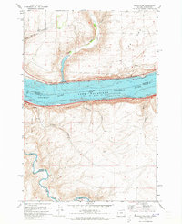
1971 Map of Sundale NW
USGS Topo · Published 1973About this map
Lake Umatilla dominates the landscape where the Columbia River forms the boundary between Oregon and Washington. This early 1970s survey captures the industrial and logistical importance of the river corridor, defined by competing rail lines on opposing banks: the Burlington Northern to the north and the Union Pacific to the south. Small settlements like Bates and Blalock sit perched along the southern shore, while the interior terrain is marked by dramatic drainages such as Swanson Canyon and Philippi Canyon. Near the western edge, the John Day River winds through The Nook before joining the main stem. This map is particularly useful for tracing the transport networks and rural outposts like Philippi situated above the river breaks before significant modern development altered the plateau character.
Find a feature on this map
25 named features on this map. Tap any name to fly to it.
Don’t see what you’re looking for? This feature index may not catch every label — zoom into the map to look around manually.
Map Details
Editions of this 1971 Sundale NW Map
2 editions found
Other maps of this area

1916 · Arlington
USGS Topo · 1:125,000

1953 · The Dalles
USGS Topo · 1:250,000

1956 · The Dalles
USGS Topo · 1:250,000

1957 · The Dalles
USGS Topo · 1:250,000

1957 · Wasco
USGS Topo · 1:62,500

1957 · Satus Pass
USGS Topo · 1:62,500

1964 · Turner Butte
USGS Topo · 1:24,000

1964 · Mc Donald
USGS Topo · 1:24,000

1965 · Goodnoe Hills
USGS Topo · 1:24,000
1965 · Dot
USGS Topo · 1:24,000