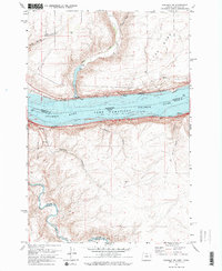
1971 Map of Sundale NW
USGS Topo · Published 1973About this map
Lake Umatilla dominates this section of the Columbia River basin, reflecting the managed water levels of the early 1970s. This stretch of the river serves as a critical transportation corridor, with the Union Pacific railroad tracking the Oregon shore and the Burlington Northern line running along the Washington side. The map documents small settlements like Blalock and Bates, which are positioned between the water and the rising canyon walls.
Find a feature on this map
24 named features on this map. Tap any name to fly to it.
Don’t see what you’re looking for? This feature index may not catch every label — zoom into the map to look around manually.
Map Details
Editions of this 1971 Sundale NW Map
2 editions found
Other maps of this area

1916 · Arlington
USGS Topo · 1:125,000

1953 · The Dalles
USGS Topo · 1:250,000

1956 · The Dalles
USGS Topo · 1:250,000

1957 · The Dalles
USGS Topo · 1:250,000

1957 · Wasco
USGS Topo · 1:62,500

1957 · Satus Pass
USGS Topo · 1:62,500

1964 · Turner Butte
USGS Topo · 1:24,000

1964 · Mc Donald
USGS Topo · 1:24,000

1965 · Goodnoe Hills
USGS Topo · 1:24,000
1965 · Dot
USGS Topo · 1:24,000