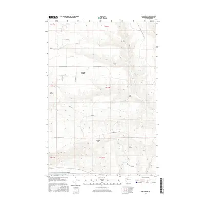
2017 Map of Luna Gulch
USGS Topo · Published 2017About this map
Pleasant Valley and the southern slopes of the Columbia Hills define this Klickitat County landscape north of the Columbia River. The terrain is characterized by a series of dramatic geographic depressions and elevations, from the narrow corridors of Luna Gulch and Badger Gulch to the prominent heights of Luna Butte. In the south, the settlement of Towal sits along the northern shore of Lake Umatilla, reflecting the vital connection between local life and the water's edge. The land is crisscrossed by namesake ranch roads such as Mauroni Ranch RD and Bill Anderson RD, suggesting a modern-day landscape still rooted in rural property boundaries and agricultural access. Along the eastern edge, Rock Cr flows through the breaks below Harrison Ridge, illustrating the drainage patterns that have shaped the high prairie and canyon lands of this region.
Find a feature on this map
32 named features on this map. Tap any name to fly to it.
Don’t see what you’re looking for? This feature index may not catch every label — zoom into the map to look around manually.
Map Details
Editions of this 2017 Luna Gulch Map
This is the sole edition of this map. No revisions or reprints were ever made.
Other maps of this area

1916 · Arlington
USGS Topo · 1:125,000

1953 · The Dalles
USGS Topo · 1:250,000

1956 · The Dalles
USGS Topo · 1:250,000

1957 · The Dalles
USGS Topo · 1:250,000

1957 · Wasco
USGS Topo · 1:62,500

1957 · Satus Pass
USGS Topo · 1:62,500

1965 · Goodnoe Hills
USGS Topo · 1:24,000
1965 · Bickleton NW
USGS Topo · 1:24,000

1971 · Quinton
USGS Topo · 1:24,000
1971 · Sundale NW
USGS Topo · 1:24,000