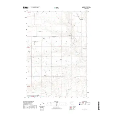
2020 Map of Luna Gulch
USGS Topo · Published 2020About this map
Pleasant Valley and the surrounding high country of Klickitat County are defined by a network of ranch roads and significant topographic relief. In the northern reaches, Harrison Ridge and Badger Gulch frame the landscape, while the southern edge descends toward the Columbia River at Towal and the waters of Lake Umatilla. The terrain is marked by distinctive local landmarks such as Luna Butte and the broad expanse of Oak Flat, illustrating a rural economy tied to the land and the river. Numerous roads, including Goldendale Bickleton Rd and Mauroni Ranch Rd, provide access to the various gulches and canyons. The Columbia Hills dominate the southern interior, with drainage systems like Luna Gulch and Rock Cr cutting through the ridges. This recent survey captures the modern road networks and land divisions while preserving the historical place names that have defined this Washington landscape for generations.
Find a feature on this map
35 named features on this map. Tap any name to fly to it.
Don’t see what you’re looking for? This feature index may not catch every label — zoom into the map to look around manually.
Map Details
Editions of this 2020 Luna Gulch Map
This is the sole edition of this map. No revisions or reprints were ever made.
Other maps of this area

1916 · Arlington
USGS Topo · 1:125,000

1953 · The Dalles
USGS Topo · 1:250,000

1956 · The Dalles
USGS Topo · 1:250,000

1957 · The Dalles
USGS Topo · 1:250,000

1957 · Wasco
USGS Topo · 1:62,500

1957 · Satus Pass
USGS Topo · 1:62,500

1965 · Goodnoe Hills
USGS Topo · 1:24,000
1965 · Bickleton NW
USGS Topo · 1:24,000

1971 · Quinton
USGS Topo · 1:24,000
1971 · Sundale NW
USGS Topo · 1:24,000