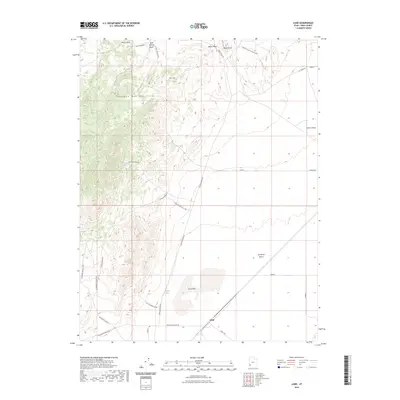
2023 Map of Lund
USGS Topo · Published 2023About this map
Lund stands as a focal point in this high-desert landscape, situated where the Escalante Desert meets the southern reaches of the Wah Wah Mountains. The topography is defined by the sharp transition from the level terrain of the Lund Flats to the complex drainages of Pfaehler Canyon and Sulfur Springs Draw. These arid lowlands are punctuated by essential water sources like Rosenberg Spring, Marsden Spring, and Prout Springs, illustrating the vital role of natural springs and deep-drilled infrastructure like Leigh Well for life and industry in Iron County. The map details a network of functional routes including the Lund Hwy and Blue Mountain Rd, which connect the settlement to remote outposts and radio infrastructure atop Broze Knoll. This modern survey documents the persistent human footprint and hydrographic patterns in a region where water availability dictates the layout of roads and landmarks.
Find a feature on this map
34 named features on this map. Tap any name to fly to it.
Don’t see what you’re looking for? This feature index may not catch every label — zoom into the map to look around manually.
Map Details
Editions of this 2023 Lund Map
This is the sole edition of this map. No revisions or reprints were ever made.
Other maps of this area

1885 · St. George
USGS Topo · 1:250,000

1891 · St. George
USGS Topo · 1:250,000

1951 · Avon
USGS Topo · 1:24,000

1951 · Avon NW
USGS Topo · 1:24,000

1953 · Richfield
USGS Topo · 1:250,000

1953 · Cedar City
USGS Topo · 1:250,000

1958 · Richfield
USGS Topo · 1:250,000

1958 · Cedar City
USGS Topo · 1:250,000

1962 · Cedar City
USGS Topo · 1:250,000
1971 · Lund
USGS Topo · 1:24,000