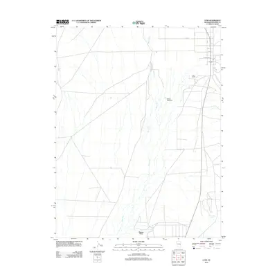
2012 Map of Lund
USGS Topo · Published 2012About this map
The settlement of Lund serves as the primary hub in this portion of White Pine County, established within a landscape defined by the drainage of the White River. The town's civic structure is marked by the Lund Post Office, while the agricultural heritage of the region is evidenced by the Lund Holding Corral and the broad expanse of Wilson Meadows. This 2012 survey illustrates a desert environment where water sources are critical to settlement patterns, as seen in the distribution of family-named water features like Douglas Spring, Lund Spring, and Jacob Springs. To the south, Ruppes Place and Indian Springs mark the transition toward more open terrain. A systematic road network, including Rollins Rd and Ivins Ln, provides the framework for this rural community, connecting isolated ranching outposts and spring-fed sites across the valley floor.
Find a feature on this map
15 named features on this map. Tap any name to fly to it.
Don’t see what you’re looking for? This feature index may not catch every label — zoom into the map to look around manually.
Map Details
Editions of this 2012 Lund Map
This is the sole edition of this map. No revisions or reprints were ever made.
Other maps of this area

1956 · Lund
USGS Topo · 1:250,000

1960 · Lund
USGS Topo · 1:250,000

1969 · Moorman Spring NW
USGS Topo · 1:24,000

1969 · Moorman Spring NE
USGS Topo · 1:24,000

1969 · Haggerty Spring
USGS Topo · 1:24,000
1977 · Brown Knoll
USGS Topo · 1:24,000
1977 · Sawmill Canyon
USGS Topo · 1:24,000
1978 · Lund
USGS Topo · 1:24,000
1978 · Douglas
USGS Topo · 1:24,000
1978 · Badger Hole Spring
USGS Topo · 1:24,000