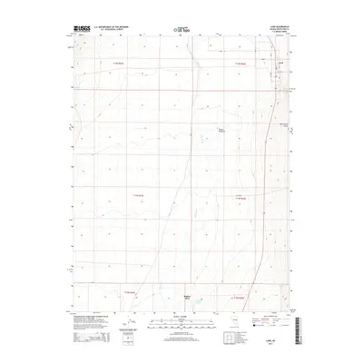
2014 Map of Lund
USGS Topo · Published 2014About this map
The White River flows through the heart of this high-desert basin, defining the fertile corridor of the White River Valley in eastern Nevada. At the northern edge of the sheet, the settlement of Lund sits at a crossroads of local life, where Main St and Center St anchor the small community. The landscape is marked by its critical water sources, including the cluster of Indian Springs and the eponymous Lund Spring, which have supported ranching and agriculture in this arid region for generations. To the south, Ruppes Place suggests the footprint of earlier homesteading efforts. The map reveals a transition from the level floor of Wilson Meadows to the rising topographic contours of the surrounding valley walls, served by rural corridors like Rollins Rd and CR-15.
Find a feature on this map
22 named features on this map. Tap any name to fly to it.
Don’t see what you’re looking for? This feature index may not catch every label — zoom into the map to look around manually.
Map Details
Editions of this 2014 Lund Map
This is the sole edition of this map. No revisions or reprints were ever made.
Other maps of this area

1956 · Lund
USGS Topo · 1:250,000

1960 · Lund
USGS Topo · 1:250,000

1969 · Moorman Spring NW
USGS Topo · 1:24,000

1969 · Moorman Spring NE
USGS Topo · 1:24,000

1969 · Haggerty Spring
USGS Topo · 1:24,000
1977 · Brown Knoll
USGS Topo · 1:24,000
1977 · Sawmill Canyon
USGS Topo · 1:24,000
1978 · Lund
USGS Topo · 1:24,000
1978 · Douglas
USGS Topo · 1:24,000
1978 · Badger Hole Spring
USGS Topo · 1:24,000