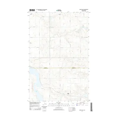
2014 Map of Lunds Valley
USGS Topo · Published 2014About this map
Lunds Valley sits at the heart of this prairie landscape, where the border of Burke and Mountrail counties divides the terrain. The map documents a rural network of section-line roads, including Kings Hwy and numerous numbered routes like 83rd St NW, that connect isolated farmsteads and community landmarks. For those tracing family history in this part of North Dakota, the map identifies specific burial sites such as Saint James Cem and Elbow Lake Bethel Cem, which serve as permanent anchors for the area's early settlement. The geography is defined by glacial depressions, most notably the expansive Powers Lake in the southwest and the smaller Elbow Lake to the northeast. This 2014 survey illustrates the persistence of small-town centers and the organized agricultural grid that continues to shape life on the northern plains.
Find a feature on this map
23 named features on this map. Tap any name to fly to it.
Don’t see what you’re looking for? This feature index may not catch every label — zoom into the map to look around manually.
Map Details
Editions of this 2014 Lunds Valley Map
This is the sole edition of this map. No revisions or reprints were ever made.
Other maps of this area

1953 · Williston
USGS Topo · 1:250,000

1957 · Williston
USGS Topo · 1:250,000

1969 · Ross NW
USGS Topo · 1:24,000
1974 · Thompson Lake
USGS Topo · 1:24,000
1974 · Helde Lake
USGS Topo · 1:24,000

1974 · Grubb Lake
USGS Topo · 1:24,000

1974 · Lostwood Lakes
USGS Topo · 1:24,000

1977 · Powers Lake
USGS Topo · 1:24,000
1978 · Lunds Valley
USGS Topo · 1:24,000

1981 · Lostwood
USGS Topo · 1:24,000