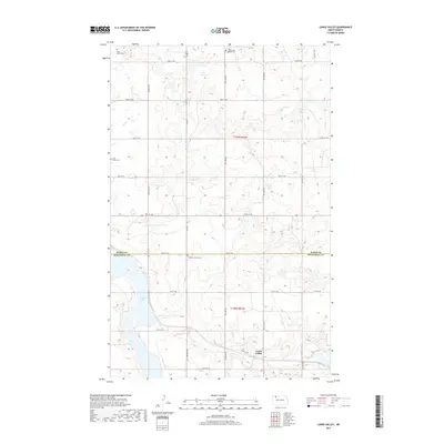
2017 Map of Lunds Valley
USGS Topo · Published 2017About this map
Lunds Valley occupies the south-central portion of this Northwest North Dakota landscape, where the prairie is defined by a series of kettle lakes and potholes common to the Glaciated Missouri Plateau. The settlement pattern remains largely agricultural, structured by a rigid section-line road grid that includes 78th St NW and 75th St NW. These routes connect dispersed homesteads and rural landmarks that provide essential ties for genealogists and local historians. The map records several dedicated burial sites, including the Saint James Cem and Bethel Lutheran Cem, reflecting the early Norwegian and religious foundations of the area. Significant water bodies like Powers Lake and Elbow Lake serve as natural breaks in the cultivated fields, while the boundary between Burke Co and Mountrail Co divides the northern and southern tiers of the township.
Find a feature on this map
20 named features on this map. Tap any name to fly to it.
Don’t see what you’re looking for? This feature index may not catch every label — zoom into the map to look around manually.
Map Details
Editions of this 2017 Lunds Valley Map
This is the sole edition of this map. No revisions or reprints were ever made.
Other maps of this area

1953 · Williston
USGS Topo · 1:250,000

1957 · Williston
USGS Topo · 1:250,000

1969 · Ross NW
USGS Topo · 1:24,000
1974 · Thompson Lake
USGS Topo · 1:24,000
1974 · Helde Lake
USGS Topo · 1:24,000

1974 · Grubb Lake
USGS Topo · 1:24,000

1974 · Lostwood Lakes
USGS Topo · 1:24,000

1977 · Powers Lake
USGS Topo · 1:24,000
1978 · Lunds Valley
USGS Topo · 1:24,000

1981 · Lostwood
USGS Topo · 1:24,000