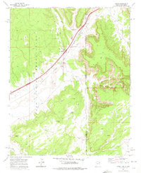
1971 Map of Lupton
USGS Topo · Published 1975About this map
The Navajo Indian Reservation landscape surrounding Lupton is defined by its deep reliance on scattered water sources and the vital transport corridor of the Puerco River valley. In this 1971 survey, the community of Lupton serves as a central point for the Lupton Chapter House and local infrastructure like the Gaging Station and Borrow Pit. The map captures the heavy industrial presence of the Atchison Topeka and Santa Fe railroad and Interstate 40 as they parallel the river, cutting through the high desert terrain. Local life is mapped through family and place-named water features like Begay Well, Tse De Tha Well, and Keetsoel Spring, which reveal the sparse but essential points of habitation. Along the state line of Arizona and New Mexico, numerous jeep trails wind into the more remote canyons, providing access to landmarks like Millers Cave and Slims Spring.
Find a feature on this map
22 named features on this map. Tap any name to fly to it.
Don’t see what you’re looking for? This feature index may not catch every label — zoom into the map to look around manually.
Map Details
Editions of this 1971 Lupton Map
This is the sole edition of this map. No revisions or reprints were ever made.
Other maps of this area

1886 · Wingate
USGS Topo · 1:250,000

1886 · Fort Defiance
USGS Topo · 1:250,000

1892 · Fort Defiance
USGS Topo · 1:250,000

1892 · Wingate
USGS Topo · 1:250,000

1954 · Gallup
USGS Topo · 1:250,000

1958 · Gallup
USGS Topo · 1:250,000

1959 · Gallup
USGS Topo · 1:250,000

1962 · Gallup
USGS Topo · 1:250,000

1963 · Manuelito
USGS Topo · 1:24,000

1963 · Jones Ranch School
USGS Topo · 1:24,000
Featured Places
- Fort Defiance Agency
- Eastern Navajo Agency, NM
- Lupton, Fort Defiance Agency
- McKinley County, NM
- Apache County, AZ