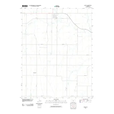
2009 Map of Luray
USGS Topo · Published 2009About this map
The town of Luray anchors the northern edge of this Russell County landscape, situated at the junction of Waldo Rd and the local road network. The surrounding terrain is defined by a dense drainage system of prairie creeks, most notably the winding paths of Wolf Creek and its tributary, West Fork Wolf Creek. Further east, Coon Creek and Fourmile Creek carve through the agricultural sections, illustrating the water-rich topography that historically supported regional farming. Away from the primary settlement, the Motor Cross Race Track stands out as a unique modern landmark among the grid of rural routes such as Paradise Rd and Fairport Rd. This survey documents a quiet rural corridor where long-established section roads and natural waterways continue to dictate the local geography.
Find a feature on this map
23 named features on this map. Tap any name to fly to it.
Don’t see what you’re looking for? This feature index may not catch every label — zoom into the map to look around manually.
Map Details
Editions of this 2009 Luray Map
This is the sole edition of this map. No revisions or reprints were ever made.
Other maps of this area

1896 · Osborne
USGS Topo · 1:125,000

1896 · Russell
USGS Topo · 1:125,000

1955 · Great Bend
USGS Topo · 1:250,000

1955 · Beloit
USGS Topo · 1:250,000

1957 · Great Bend
USGS Topo · 1:250,000

1958 · Great Bend
USGS Topo · 1:250,000

1959 · Beloit
USGS Topo · 1:250,000
1967 · Dorrance NW
USGS Topo · 1:24,000

1967 · Russell
USGS Topo · 1:24,000
1967 · Dorrance NE
USGS Topo · 1:24,000