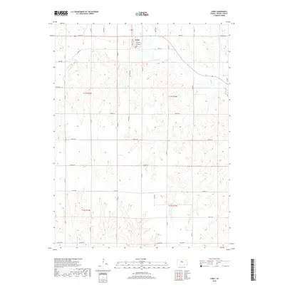
2018 Map of Luray
USGS Topo · Published 2018About this map
Luray sits at the northern edge of this Russell County landscape, where the street grid of Kansas Ave and Russell Co Ave meets the surrounding agricultural section lines. The topography is defined by the dendritic drainage patterns of Wolf Cr and its tributaries, including W Fork Wolf Cr and Fourmile Cr. These seasonal waterways carve subtle breaks into the high plains, influencing the placement of local thoroughfares like Waldo Rd and Paradise Rd. The map illustrates a strictly organized rural infrastructure, where a network of named roads such as Amherst Rd and Fairport Rd connects dispersed farmsteads across the township lines of T11S and T12S. This layout reflects the enduring influence of the Public Land Survey System on the development of central Kansas, maintaining a pattern of movement and land use established over a century ago.
Find a feature on this map
35 named features on this map. Tap any name to fly to it.
Don’t see what you’re looking for? This feature index may not catch every label — zoom into the map to look around manually.
Map Details
Editions of this 2018 Luray Map
This is the sole edition of this map. No revisions or reprints were ever made.
Other maps of this area

1896 · Osborne
USGS Topo · 1:125,000

1896 · Russell
USGS Topo · 1:125,000

1955 · Great Bend
USGS Topo · 1:250,000

1955 · Beloit
USGS Topo · 1:250,000

1957 · Great Bend
USGS Topo · 1:250,000

1958 · Great Bend
USGS Topo · 1:250,000

1959 · Beloit
USGS Topo · 1:250,000
1967 · Dorrance NW
USGS Topo · 1:24,000

1967 · Russell
USGS Topo · 1:24,000
1967 · Dorrance NE
USGS Topo · 1:24,000