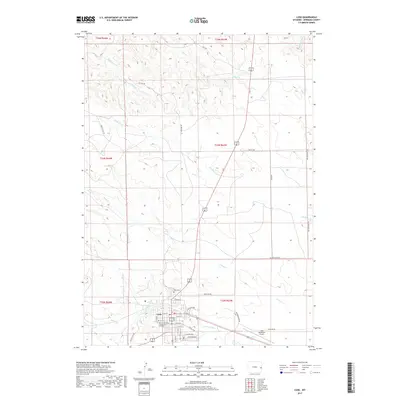
2017 Map of Lusk
USGS Topo · Published 2017About this map
Lusk serves as the focal point of this eastern Wyoming landscape, situated at a vital junction of road and rail where the Niobrara River flows eastward. The town's grid is detailed with specific local landmarks such as the Eastern Wyoming College Lusk Outreach and Lusk Municipal Airport. This modern survey reveals a region defined by its drainage network, where multiple watercourses including Duck Cr and Old Woman Cr carve through the high plains. The transition from the structured street names of the town, like Lincoln Way and Overland Way, to the rural character of named tracks such as Beer Can Rd and Ruffing RD illustrates the proximity of this community to the surrounding cattle country. For those looking into local genealogy, the Lusk Cem is clearly indicated north of the town center, providing a fixed point for family history research within the county seat.
Find a feature on this map
40 named features on this map. Tap any name to fly to it.
Don’t see what you’re looking for? This feature index may not catch every label — zoom into the map to look around manually.
Map Details
Editions of this 2017 Lusk Map
This is the sole edition of this map. No revisions or reprints were ever made.
Other maps of this area

1954 · Torrington
USGS Topo · 1:250,000

1958 · Torrington
USGS Topo · 1:250,000

1974 · Silver Springs
USGS Topo · 1:24,000
1974 · Reynolds Spring
USGS Topo · 1:24,000
1978 · Node
USGS Topo · 1:24,000

1981 · Lusk
USGS Topo · 1:24,000
1981 · Signature Rock
USGS Topo · 1:24,000

1981 · Manville
USGS Topo · 1:24,000
1981 · Hat Rock
USGS Topo · 1:24,000
1981 · Hat Creek
USGS Topo · 1:24,000