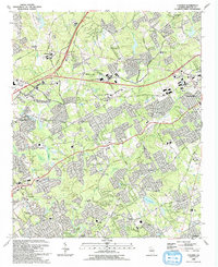
1992 Map of Luxomni
USGS Topo · Published 1993About this map
Luxomni and Gloster sit along the Seaboard System railroad line in this detailed study of Gwinnett County's suburban expansion in the early 1990s. The landscape reflects a transition from rural crossroads to developed residential areas, characterized by numerous community institutions such as Luxomni Ch, Gwin Oaks Sch, and the expansive Bethesda Community Park. This era of growth is further evidenced by the complex road network, including the Northeast Expressway and Satellite Boulevard, which bypasses the older settlement patterns centered on smaller creeks.
Find a feature on this map
72 named features on this map. Tap any name to fly to it.
Don’t see what you’re looking for? This feature index may not catch every label — zoom into the map to look around manually.
Map Details
Editions of this 1992 Luxomni Map
This is the sole edition of this map. No revisions or reprints were ever made.
Other maps of this area

1888 · Atlanta
USGS Topo · 1:125,000

1890 · Suwanee
USGS Topo · 1:125,000

1890 · Atlanta
USGS Topo · 1:125,000

1891 · Gainesville
USGS Topo · 1:125,000

1892 · Atlanta
USGS Topo · 1:125,000

1894 · Suwanee
USGS Topo · 1:125,000

1895 · Atlanta
USGS Topo · 1:125,000

1896 · Monroe
USGS Topo · 1:125,000

1953 · Atlanta
USGS Topo · 1:250,000

1953 · Athens
USGS Topo · 1:250,000