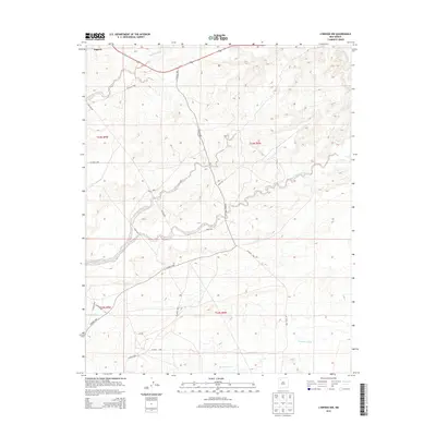
2013 Map of Lybrook NW
USGS Topo · Published 2013About this map
Nageezi sits at the northwestern edge of this high-desert landscape in the Eastern Navajo Agency, serving as a primary point of human settlement amidst a network of ephemeral watercourses. The drainage patterns are defined by the wide, sandy beds of Kimbeto Wash, Betonnie Tsosie Wash, and Escavada Wash, which carve across the terrain. A complex system of rural infrastructure is visible, including the prominent Pipeline Rd and numerous county routes such as Co Road 7900 and Co Road 7950. These roads follow the natural contours of the land, connecting scattered homesteads and oil or gas developments to the larger regional network. The map provides a clear look at the public land survey system, specifically documenting portions of t23n r9w, t23n r8w, t22n r9w, and t22n r8w, which organize the remote territory into its administrative and residential components.
Find a feature on this map
20 named features on this map. Tap any name to fly to it.
Don’t see what you’re looking for? This feature index may not catch every label — zoom into the map to look around manually.
Map Details
Editions of this 2013 Lybrook NW Map
This is the sole edition of this map. No revisions or reprints were ever made.
Other maps of this area

1889 · Largo
USGS Topo · 1:250,000

1895 · Largo
USGS Topo · 1:250,000

1954 · Aztec
USGS Topo · 1:250,000

1958 · Aztec
USGS Topo · 1:250,000

1959 · Nageezi
USGS Topo · 1:62,500

1962 · Aztec
USGS Topo · 1:250,000

1965 · Aztec
USGS Topo · 1:250,000

1966 · Lybrook NW
USGS Topo · 1:24,000
1966 · Sargent Ranch
USGS Topo · 1:24,000
1966 · Lybrook SE
USGS Topo · 1:24,000