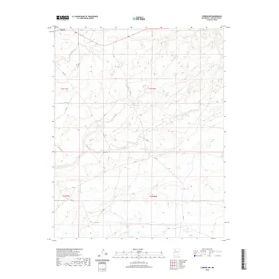
2020 Map of Lybrook NW
USGS Topo · Published 2020About this map
Nageezi sits at the northern edge of this high-desert landscape in San Juan County, where the terrain is defined by a dense network of ephemeral drainage systems. These waterways, including Kimbeto Wash, Betonnie Tsosie Wash, and Escavada Wash, carve intricate patterns through the geography, illustrating the erosive power of seasonal water in the Eastern Navajo Agency. The map captures a moment in the modern era where infrastructure and traditional land divisions meet. A web of local routes and service roads like Pipeline Rd, Co Rd 7890, and Co Rd 7810 cross the township lines of T23N R9W and T22N R8W, reflecting the region's role in resource transportation and land management. The absence of dense settlement highlights the expansive, open character of this part of New Mexico, dominated by the natural geometry of the washes and the functional grid of industrial and county roadways.
Find a feature on this map
21 named features on this map. Tap any name to fly to it.
Don’t see what you’re looking for? This feature index may not catch every label — zoom into the map to look around manually.
Map Details
Editions of this 2020 Lybrook NW Map
This is the sole edition of this map. No revisions or reprints were ever made.
Other maps of this area

1889 · Largo
USGS Topo · 1:250,000

1895 · Largo
USGS Topo · 1:250,000

1954 · Aztec
USGS Topo · 1:250,000

1958 · Aztec
USGS Topo · 1:250,000

1959 · Nageezi
USGS Topo · 1:62,500

1962 · Aztec
USGS Topo · 1:250,000

1965 · Aztec
USGS Topo · 1:250,000

1966 · Lybrook NW
USGS Topo · 1:24,000
1966 · Sargent Ranch
USGS Topo · 1:24,000
1966 · Lybrook SE
USGS Topo · 1:24,000