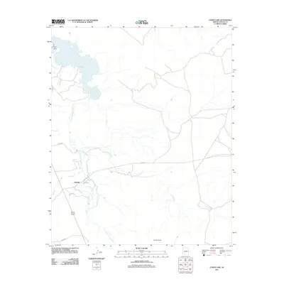
2011 Map of Lyman Lake
USGS Topo · Published 2011About this map
Richville sits at a crossroads of water and desert in this Apache County landscape, where the Little Colorado River winds its way toward the larger reservoir at Lyman Lake. This 2011 survey details a region defined by its hydrography, showing how seasonal and permanent water sources like Coyote Creek, Vigil Run, and Carnero Creek converge in the arid high country. The map captures the infrastructure supporting the local community, from the Lyman Lake Marina to the network of rural routes such as Co RD 4008 and Co RD 4016. Grounded in the geological reality of the Colorado Plateau, features like Scraper Knoll and Neilson Spring provide specific landmarks for those tracing the development of ranching and recreation in eastern Arizona.
Find a feature on this map
15 named features on this map. Tap any name to fly to it.
Don’t see what you’re looking for? This feature index may not catch every label — zoom into the map to look around manually.
Map Details
Editions of this 2011 Lyman Lake Map
This is the sole edition of this map. No revisions or reprints were ever made.
Other maps of this area

1886 · St Johns
USGS Topo · 1:250,000

1892 · St Johns
USGS Topo · 1:250,000

1954 · Saint Johns
USGS Topo · 1:250,000

1957 · Saint Johns
USGS Topo · 1:250,000

1958 · Saint Johns
USGS Topo · 1:250,000

1962 · Saint Johns
USGS Topo · 1:250,000

1968 · Springerville NW
USGS Topo · 1:24,000

1969 · Coyote Hills
USGS Topo · 1:24,000
1969 · Springerville
USGS Topo · 1:24,000

1971 · Mesa Parada NW
USGS Topo · 1:24,000