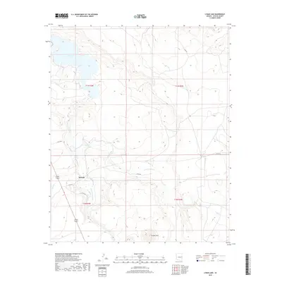
2018 Map of Lyman Lake
USGS Topo · Published 2018About this map
Lyman Lake dominates the northern reaches of this high-plateau landscape, created by the impoundment of the Little Colorado River. The small settlement of Richville sits further south along the river valley, serving as a focal point for local transportation routes like 180 191 and various county roads. This arid environment is defined by its intermittent drainage systems, including Coyote Cr, Carnero Cr, and Vigil Run, which channel seasonal water through the broken terrain. Rising above the southern plains, Scraper Knoll provides a distinct landmark near the convergence of these creek beds. The presence of Neilson Spring highlights the critical importance of water sources in this part of Apache County, where the transition from riparian corridors to high desert uplands dictates the pattern of human occupancy and land use.
Find a feature on this map
18 named features on this map. Tap any name to fly to it.
Don’t see what you’re looking for? This feature index may not catch every label — zoom into the map to look around manually.
Map Details
Editions of this 2018 Lyman Lake Map
This is the sole edition of this map. No revisions or reprints were ever made.
Other maps of this area

1886 · St Johns
USGS Topo · 1:250,000

1892 · St Johns
USGS Topo · 1:250,000

1954 · Saint Johns
USGS Topo · 1:250,000

1957 · Saint Johns
USGS Topo · 1:250,000

1958 · Saint Johns
USGS Topo · 1:250,000

1962 · Saint Johns
USGS Topo · 1:250,000

1968 · Springerville NW
USGS Topo · 1:24,000

1969 · Coyote Hills
USGS Topo · 1:24,000
1969 · Springerville
USGS Topo · 1:24,000

1971 · Mesa Parada NW
USGS Topo · 1:24,000