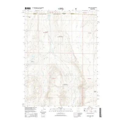
2014 Map of Lyman Lake
USGS Topo · Published 2014About this map
Old Blacks Fork Commissary sits as a notable point of human activity within the high-elevation landscape of the Wasatch National Forest in this 2014 survey. The area is defined by the complex drainage system of the Blacks Fork river, including its West Fork, Middle Fork, and East Fork branches. These waterways flow northward through the Uinta Mountains toward the Meeks Cabin Reservoir, which straddles the Wyoming-Utah border. Near the center of the quadrangle, recreational and topographical features such as Lyman Lake, Little Lyman Lake, and the Little Lyman Lake Campground indicate the region's importance for modern outdoor use. To the southeast, Mansfield Meadows provides a distinct break in the mountainous terrain, while names like Beaver Dam Hollow reflect the local wildlife and geography that have shaped the region's identity.
Find a feature on this map
27 named features on this map. Tap any name to fly to it.
Don’t see what you’re looking for? This feature index may not catch every label — zoom into the map to look around manually.
Map Details
Editions of this 2014 Lyman Lake Map
This is the sole edition of this map. No revisions or reprints were ever made.
Other maps of this area

1885 · Uinta
USGS Topo · 1:250,000

1901 · Hayden Peak
USGS Topo · 1:125,000

1903 · Hayden Peak
USGS Topo · 1:125,000

1905 · Gilbert Peak
USGS Topo · 1:125,000

1906 · Gilbert Peak
USGS Topo · 1:125,000

1954 · Salt Lake City
USGS Topo · 1:250,000

1954 · Ogden
USGS Topo · 1:250,000

1958 · Ogden
USGS Topo · 1:250,000

1958 · Salt Lake City
USGS Topo · 1:250,000

1960 · Ogden
USGS Topo · 1:250,000