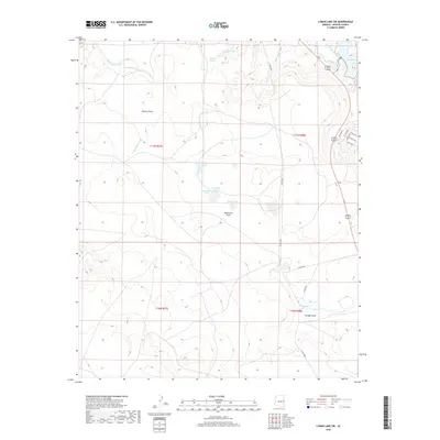
2018 Map of Lyman Lake SW
USGS Topo · Published 2018About this map
Lyman Lake and the Little Colorado River define the northeastern corner of this high-desert landscape in Apache County. The terrain is a network of seasonal drainages and essential water sources, including several named springs like Mud Spring, Chimney Spring, and Straddling Spring that served as critical landmarks for ranchers and travelers. Significant topographic features like Mallory Draw, Atascocita Draw, and Cienega Draw funnel water through the arid range toward small, localized basins such as Wiregrass Lake and Woods Lake. The presence of The Cienega and Wiltbank Spring suggests areas of higher moisture and potentially long-standing agricultural or grazing significance in this section of the Colorado Plateau. A sparse network of county roads, such as Co RD 4365 and Co RD 4366, provides access across the township boundaries.
Find a feature on this map
30 named features on this map. Tap any name to fly to it.
Don’t see what you’re looking for? This feature index may not catch every label — zoom into the map to look around manually.
Map Details
Editions of this 2018 Lyman Lake SW Map
This is the sole edition of this map. No revisions or reprints were ever made.
Other maps of this area

1886 · St Johns
USGS Topo · 1:250,000

1892 · St Johns
USGS Topo · 1:250,000

1954 · Saint Johns
USGS Topo · 1:250,000

1957 · Saint Johns
USGS Topo · 1:250,000

1958 · Saint Johns
USGS Topo · 1:250,000

1962 · Saint Johns
USGS Topo · 1:250,000

1968 · Springerville NW
USGS Topo · 1:24,000

1969 · Whiting Knoll
USGS Topo · 1:24,000
1969 · Springerville
USGS Topo · 1:24,000
1971 · Cerro Hueco
USGS Topo · 1:24,000