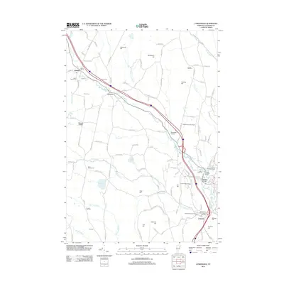
2012 Map of Lyndonville
USGS Topo · Published 2012About this map
Lyndon and Lyndon Center anchor the southeastern corner of this Caledonia County landscape, where the Passumpsic River and Miller Run converge. The area is defined by its historic infrastructure, most notably a series of spans including the Centre Covered Bridge, the Bradley Covered Bridge, and the Chamberlin Mill Covered Bridge. These structures, alongside the Old Schoolhouse Bridge, reflect a long-standing commitment to maintaining local transport across the river networks that fueled early industry.
Find a feature on this map
132 named features on this map. Tap any name to fly to it.
Don’t see what you’re looking for? This feature index may not catch every label — zoom into the map to look around manually.
Map Details
Editions of this 2012 Lyndonville Map
This is the sole edition of this map. No revisions or reprints were ever made.
Other maps of this area

1931 · Littleton
USGS Topo · 1:62,500

1932 · Littleton
USGS Topo · 1:48,000

1935 · Littleton
USGS Topo · 1:62,500

1935 · Lyndonville
USGS Topo · 1:48,000

1938 · St. Johnsbury
USGS Topo · 1:48,000

1939 · Lyndonville
USGS Topo · 1:62,500

1943 · St. Johnsbury
USGS Topo · 1:62,500
1949 · St. Johnsbury
USGS Topo · 1:62,500

1950 · Lake Champlain
USGS Topo · 1:250,000

1950 · Lewiston
USGS Topo · 1:250,000