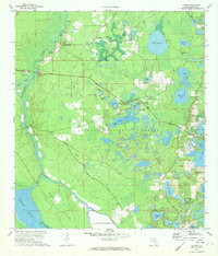
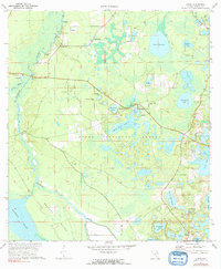
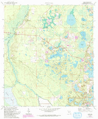
1970 Map of Lynne
USGS Topo · Published 1973About this map
The Oklawaha River carves a winding path along the western edge of this 1970 landscape, defining a region where the dense forest of the Ocala National Forest meets a complex network of wetlands. In the north, small river settlements like Grahamsville and Conner are linked by landings such as Caldwell Landing and Turkey Landing, reflecting a history tied to river transit. Moving inland, the terrain is dotted with dozens of named water bodies, including the expansive Lake Bryant and the distinctive Church Lake Prairie. Local social life in this era centered around institutions like the Ocklawaha Bridge Ch and East Marion Sch near the crossroads of Lynne. To the south, the environment transitions into the broad reaches of Heather Island and Marshall Swamp, highlighting the intricate hydrology that shaped development in central Florida.
Find a feature on this map
46 named features on this map. Tap any name to fly to it.
Don’t see what you’re looking for? This feature index may not catch every label — zoom into the map to look around manually.
Map Details
Editions of this 1970 Lynne Map
3 editions found
Other maps of this area

1893 · Citra
USGS Topo · 1:62,500

1895 · Citra
USGS Topo · 1:62,500

1895 · Ocala
USGS Topo · 1:62,500

1954 · Gainesville
USGS Topo · 1:250,000

1954 · Daytona Beach
USGS Topo · 1:250,000

1958 · Daytona Beach
USGS Topo · 1:250,000

1958 · Gainesville
USGS Topo · 1:250,000

1959 · Gainesville
USGS Topo · 1:250,000

1964 · Daytona Beach
USGS Topo · 1:250,000

1967 · Ocala East
USGS Topo · 1:24,000