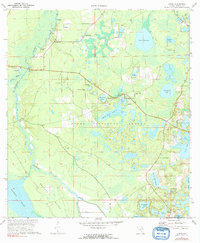
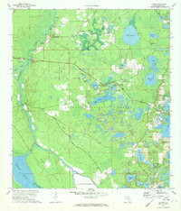
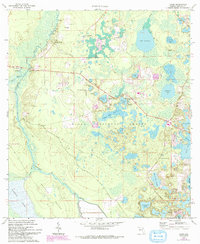
1970 Map of Lynne
USGS Topo · Published 1991About this map
The Oklawaha River carves a winding path through the heart of the Ocala National Forest, defining a landscape where river landings and early Florida settlements like Lynne and Grahamsville once served as vital interior hubs. In this 1970 survey, the transition from the river bottomlands of Marshall Swamp to the pine-studded uplands is marked by a high density of small lakes, such as Church Lake and Redwater Lake. Evidence of local infrastructure includes the Oklawaha Bridge Ch and East Marion Sch, while historical river crossings like Sharps Ferry and the Old Ocklawaha Bridge indicate older transportation patterns. The southern reaches are anchored by Lake Bryant, surrounded by pockets of activity like the Landing Strip and Radio Tower near Electra, reflecting a mid-century balance of remote forestry and emerging community development.
Find a feature on this map
52 named features on this map. Tap any name to fly to it.
Don’t see what you’re looking for? This feature index may not catch every label — zoom into the map to look around manually.
Map Details
Editions of this 1970 Lynne Map
3 editions found
Other maps of this area

1893 · Citra
USGS Topo · 1:62,500

1895 · Citra
USGS Topo · 1:62,500

1895 · Ocala
USGS Topo · 1:62,500

1954 · Gainesville
USGS Topo · 1:250,000

1954 · Daytona Beach
USGS Topo · 1:250,000

1958 · Daytona Beach
USGS Topo · 1:250,000

1958 · Gainesville
USGS Topo · 1:250,000

1959 · Gainesville
USGS Topo · 1:250,000

1964 · Daytona Beach
USGS Topo · 1:250,000

1967 · Ocala East
USGS Topo · 1:24,000