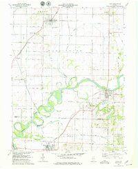
1978 Map of Lyons
USGS Topo · Published 1979About this map
The White River carves a winding path across this landscape, defining the boundaries between Greene, Daviess, and Knox counties. The era’s transportation network is anchored by the Conrail lines that intersect at Bushrod and Beehunter, serving as a backbone for small agricultural hubs like Lyons and Newberry. These rail junctions reflect a period when rural logistics relied heavily on fixed trackage to move goods from the surrounding fields and Oil Wells to larger markets.
Find a feature on this map
69 named features on this map. Tap any name to fly to it.
Don’t see what you’re looking for? This feature index may not catch every label — zoom into the map to look around manually.
Map Details
Editions of this 1978 Lyons Map
2 editions found
Other maps of this area

1908 · Bloomfield
USGS Topo · 1:62,500

1938 · Switz City
USGS Topo · 1:24,000

1940 · Linton
USGS Topo · 1:24,000

1943 · Lyons
USGS Topo · 1:24,000

1943 · Sandborn
USGS Topo · 1:24,000

1943 · Plainville
USGS Topo · 1:24,000

1943 · Epsom
USGS Topo · 1:24,000

1947 · Switz City
USGS Topo · 1:24,000

1947 · Linton
USGS Topo · 1:24,000

1950 · Switz City
USGS Topo · 1:24,000