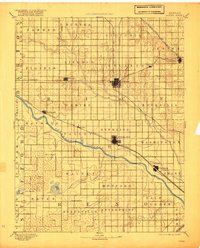
1894 Map of Lyons
USGS Topo · Published 1920About this map
The Arkansas River carves a diagonal path across this late nineteenth-century landscape, defining the agricultural and rail development of central Kansas. Major hubs like Lyons and Sterling are shown at the intersection of critical transit corridors, including the Atchison Topeka and Santa Fe Railroad and the St. Louis and San Francisco Railway. These lines facilitated the transport of grain and livestock, anchoring settlements such as Nickerson and Little River. Away from the rail lines, the topography reveals the natural marshy character of the region, specifically Black Marsh and Salt Marsh in the southwest. The presence of the Huntsville P.O. and smaller stops like Mitchell and Alden illustrate the dense network of rural post offices and townships that supported the homesteading era before later twentieth-century consolidation changed the rural footprint.
Find a feature on this map
50 named features on this map. Tap any name to fly to it.
Don’t see what you’re looking for? This feature index may not catch every label — zoom into the map to look around manually.
Map Details
Editions of this 1894 Lyons Map
5 editions found

Other maps of this area

1889 · Cheney
USGS Topo · 1:125,000

1891 · Great Bend
USGS Topo · 1:125,000

1891 · Hutchinson
USGS Topo · 1:125,000

1891 · Cheney
USGS Topo · 1:125,000

1892 · Salina
USGS Topo · 1:125,000

1892 · Kingman
USGS Topo · 1:125,000

1892 · Pratt
USGS Topo · 1:125,000

1893 · Great Bend
USGS Topo · 1:125,000

1893 · Hutchinson
USGS Topo · 1:125,000

1894 · Ellsworth
USGS Topo · 1:125,000