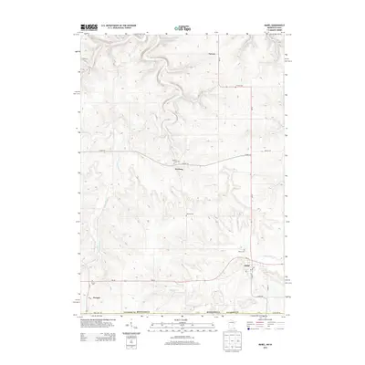
2013 Map of Mabel
USGS Topo · Published 2013About this map
Mabel and the surrounding Fillmore County countryside are defined by a network of dendritic stream valleys including Riceford Cr and Wisel Cr. This 2013 survey illustrates the local settlement pattern, where small hubs like Prosper and Newburg are linked by a grid of county roads and state highways such as MN-44 and MN-43. The map documents numerous community landmarks essential for genealogical research, including the Newburg Cem, Garness Cem, and Prosper Cem. Near the southern border, the State Line Rd follows the political boundary with Iowa, while the village of Mabel itself shows a concentrated street plan featuring S Main St and Robert St. The landscape transitions from high, flat agricultural plateaus to the deeply carved ravines of Donaldson Cr and Sorenson Cr.
Find a feature on this map
27 named features on this map. Tap any name to fly to it.
Don’t see what you’re looking for? This feature index may not catch every label — zoom into the map to look around manually.
Map Details
Editions of this 2013 Mabel Map
This is the sole edition of this map. No revisions or reprints were ever made.
Other maps of this area

1906 · Decorah
USGS Topo · 1:125,000

1958 · La Crosse
USGS Topo · 1:250,000

1961 · La Crosse
USGS Topo · 1:250,000

1965 · La Crosse
USGS Topo · 1:250,000

1965 · Mabel
USGS Topo · 1:24,000

1965 · Spring Grove
USGS Topo · 1:24,000

1965 · Canton
USGS Topo · 1:24,000

1965 · Yucatan
USGS Topo · 1:24,000

1965 · Bratsberg
USGS Topo · 1:24,000
1965 · Lanesboro
USGS Topo · 1:24,000