
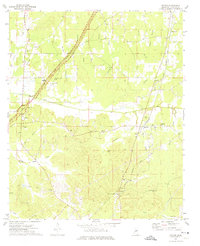
1972 Map of Maben
USGS Topo · Published 1974About this map
Maben and Mathiston serve as the primary hubs of activity in this 1970s landscape, where the intersection of the Gulf Mobile and Ohio and Illinois Central railroads once shaped local commerce. The surveying of this region at the start of the 1970s reveals a community deeply rooted in its rural institutions, with numerous houses of worship such as Marvin Hill Ch, Harpole Chapel, and Good Hope Ch scattered across the undulating terrain.
Find a feature on this map
38 named features on this map. Tap any name to fly to it.
Don’t see what you’re looking for? This feature index may not catch every label — zoom into the map to look around manually.
Map Details
Editions of this 1972 Maben Map
This is the sole edition of this map. No revisions or reprints were ever made.
Other maps of this area

1953 · West Point
USGS Topo · 1:250,000

1958 · West Point
USGS Topo · 1:250,000

1959 · Pheba
USGS Topo · 1:62,500

1963 · West Point
USGS Topo · 1:250,000

1965 · Longview
USGS Topo · 1:24,000

1972 · Sapa
USGS Topo · 1:24,000

1972 · Hohenlinden
USGS Topo · 1:24,000

1972 · Mantee
USGS Topo · 1:24,000

1972 · Double Springs
USGS Topo · 1:24,000
1972 · Reform
USGS Topo · 1:24,000