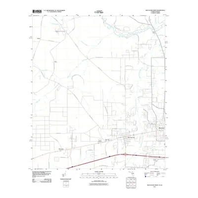
2011 Map of Macclenny West
USGS Topo · Published 2011About this map
Saint Marys River meanders along the northern boundary of this Baker County landscape, defining the border as it flows past Smith Bridge. The map details a transition from the agricultural and wooded north, where the Cuyler Field airstrip and scattered settlements like Kenny sit, to the developing residential corridors in the south. The communities of Glen Saint Mary and Macclenny serve as the primary hubs of activity, linked by a network of rural roads such as County Hwy-125 and Claude Harvey Rd. Local history and genealogy are preserved in sites like Turner Cemetery and Woodlawn Cemetery, while the Baker Fire Control Headquarters at Pine Top indicates the importance of timber management in the region. Numerous tributaries, including Cedar Creek and Daugherty Branch, weave through the terrain, illustrating the hydrologic connection to the larger river system.
Find a feature on this map
60 named features on this map. Tap any name to fly to it.
Don’t see what you’re looking for? This feature index may not catch every label — zoom into the map to look around manually.
Map Details
Editions of this 2011 Macclenny West Map
This is the sole edition of this map. No revisions or reprints were ever made.
Other maps of this area

1917 · Macclenny
USGS Topo · 1:62,500

1918 · Lawtey
USGS Topo · 1:62,500

1918 · Macclenny
USGS Topo · 1:62,500

1954 · Valdosta
USGS Topo · 1:250,000

1958 · Valdosta
USGS Topo · 1:250,000

1959 · Valdosta
USGS Topo · 1:250,000

1963 · Sanderson South
USGS Topo · 1:24,000

1969 · Sanderson North
USGS Topo · 1:24,000
1969 · Taylor
USGS Topo · 1:24,000
1970 · Manning
USGS Topo · 1:24,000