
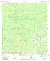
1969 Map of Sanderson North
USGS Topo · Published 1971About this map
The Osceola National Forest dominates this section of Baker County, where the landscape is defined by vast pine flatwoods and drainage basins like Hurricane Bay. Near the southern border, the settlement of Sanderson serves as a hub for local life, situated along the Seaboard Coast Line railroad. This 1969 survey captures the community structure of the era, anchored by several local institutions such as Central School and St Johns Church. Further north, an Old Railroad Grade cuts through the forest, hinting at earlier timber or transport routes that preceded the modern rail line. The northern boundary is marked by the winding course of the St Marys River and its tributaries, including Middle Prong and Calkins Creek, which move through the low-lying terrain. Scattered homesteads and family landmarks like Dobson are connected by a network of rural routes, including Dinkins Road and Cedar Road.
Find a feature on this map
21 named features on this map. Tap any name to fly to it.
Don’t see what you’re looking for? This feature index may not catch every label — zoom into the map to look around manually.
Map Details
Editions of this 1969 Sanderson North Map
2 editions found
Other maps of this area

1917 · Macclenny
USGS Topo · 1:62,500

1918 · Lawtey
USGS Topo · 1:62,500

1918 · Macclenny
USGS Topo · 1:62,500

1954 · Valdosta
USGS Topo · 1:250,000

1958 · Valdosta
USGS Topo · 1:250,000

1959 · Valdosta
USGS Topo · 1:250,000

1963 · Olustee
USGS Topo · 1:24,000

1963 · Sanderson South
USGS Topo · 1:24,000

1969 · Sanderson NW
USGS Topo · 1:24,000
1969 · Big Gum Swamp
USGS Topo · 1:24,000