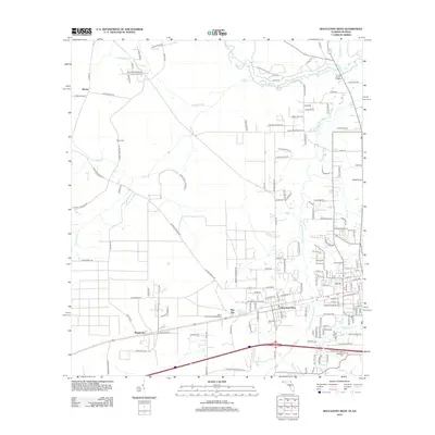
2012 Map of Macclenny West
USGS Topo · Published 2012About this map
Glen Saint Mary serves as the primary hub of this Baker County landscape, situated where the S Prong Saint Marys River winds through the eastern terrain. The map captures a moment of modern rural development, with small residential nodes like Margaretta, Pine Top, and Kenny scattered across a network of country roads. Local aviation is represented by Cuyler Field Airport in the north and Thrifts Airport near the Georgia border, highlighting the area's spread-out nature. Significant for genealogists are the locations of Woodlawn Cem and Turner Cem, which anchor the history of local families to specific land tracts. Waterways like Cedar Cr and Daugherty Br define the drainage of this flatland before reaching the main stem of the Saint Marys River.
Find a feature on this map
148 named features on this map. Tap any name to fly to it.
Don’t see what you’re looking for? This feature index may not catch every label — zoom into the map to look around manually.
Map Details
Editions of this 2012 Macclenny West Map
This is the sole edition of this map. No revisions or reprints were ever made.
Other maps of this area

1917 · Macclenny
USGS Topo · 1:62,500

1918 · Lawtey
USGS Topo · 1:62,500

1918 · Macclenny
USGS Topo · 1:62,500

1954 · Valdosta
USGS Topo · 1:250,000

1958 · Valdosta
USGS Topo · 1:250,000

1959 · Valdosta
USGS Topo · 1:250,000

1963 · Sanderson South
USGS Topo · 1:24,000

1969 · Sanderson North
USGS Topo · 1:24,000
1969 · Taylor
USGS Topo · 1:24,000
1970 · Manning
USGS Topo · 1:24,000