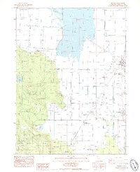
1985 Map of Macdoel
USGS Topo · Published 1986About this map
Butte Valley dominates the eastern half of this Siskiyou County landscape, where the Southern Pacific railroad runs parallel to State Highway 97 through the town of Macdoel. The mid-1980s landscape is defined by a sophisticated water management system, including an extensive Aqueduct, a Siphon, and a Road on Levee bordering Meiss Lake. This infrastructure supports agricultural operations like the Meiss Ranch, contrasting with the more natural terrain of the Klamath National Forest to the west. Local community life is centered around the Macdoel District Sch and the neighboring settlement of Mt Hebron. To the south, the Goosenest Ranger Station manages the forested elevations where Juanita Lake and Mud Lake sit at the edge of the wilderness, marking the transition from the flat agricultural valley to the wooded highlands.
Find a feature on this map
28 named features on this map. Tap any name to fly to it.
Don’t see what you’re looking for? This feature index may not catch every label — zoom into the map to look around manually.
Map Details
Editions of this 1985 Macdoel Map
This is the sole edition of this map. No revisions or reprints were ever made.
Other maps of this area

1886 · Modoc Lava Bed
USGS Topo · 1:250,000

1886 · Shasta
USGS Topo · 1:250,000

1892 · Modoc Lava-Bed
USGS Topo · 1:250,000

1894 · Shasta
USGS Topo · 1:250,000

1934 · Macdoel
USGS Topo · 1:96,000

1941 · Macdoel
USGS Topo · 1:125,000

1948 · Weed
USGS Topo · 1:250,000

1950 · Weed
USGS Topo · 1:250,000

1950 · Bray
USGS Topo · 1:62,500

1950 · Dorris
USGS Topo · 1:62,500