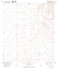
1979 Map of Mack Tanks
USGS Topo · Published 1979About this map
Fort Bliss Military Reservation (McGregor Range) dominates this high-desert landscape of Otero County, revealing the critical infrastructure required for military operations in an arid environment. The map details a network of vital water catchments known as tanks, which served both historical ranching and modern tactical needs. From Little Crockett Tank in the north to the namesake Mack Tanks near Mack Draw in the south, these localized water sources define the movement patterns across the basin. The eastern edge is carved by deep drainages including Hay Meadow Canyon and Martin Canyon, providing topographic relief against the flatter stretches where various Jeep Trails crisscross the range. This 1970s survey captures a specific moment in the land management of the McGregor Range, illustrating how natural features like Hay Meadow Tank were integrated into the reservation's geography.
Find a feature on this map
11 named features on this map. Tap any name to fly to it.
Don’t see what you’re looking for? This feature index may not catch every label — zoom into the map to look around manually.
Map Details
Editions of this 1979 Mack Tanks Map
This is the sole edition of this map. No revisions or reprints were ever made.
Other maps of this area

1940 · Bassett Lake
USGS Topo · 1:62,500

1940 · Orogrande
USGS Topo · 1:62,500

1941 · Desert
USGS Topo · 1:62,500

1943 · Pendejo Wash
USGS Topo · 1:62,500

1943 · Desert
USGS Topo · 1:62,500

1943 · Bassett Lake
USGS Topo · 1:62,500

1943 · Orogrande
USGS Topo · 1:62,500

1947 · Desert NE
USGS Topo · 1:24,000

1947 · Orogrande North
USGS Topo · 1:24,000
1948 · Orogrande South
USGS Topo · 1:24,000