
1935 Map of MacKay
USGS Topo · Published 1935About this map
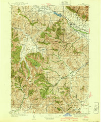
Mackay serves as the primary hub in this mid-1930s survey, situated along the Big Lost River where a complex network of irrigation infrastructure including the Sharp Ditch and Burnett Ditch supported local agriculture. The high-altitude landscape is defined by the heavy industry of the era, with prominent operations such as the Star O Hope Mine, Leadbelt Mine, and Golden Chariot Mine scattered across the surrounding peaks and basins.
Find a feature on this map
105 named features on this map. Tap any name to fly to it.
Don’t see what you’re looking for? This feature index may not catch every label — zoom into the map to look around manually.
Map Details
Editions of this 1935 MacKay Map
This is the sole edition of this map. No revisions or reprints were ever made.
Other maps of this area

1895 · Hailey
USGS Topo · 1:125,000

1897 · Hailey
USGS Topo · 1:125,000

1929 · Bayhorse
USGS Topo · 1:125,000

1935 · Borah Peak
USGS Topo · 1:125,000

1938 · Borah Peak
USGS Topo · 1:125,000
1940 · Mackay
USGS Topo · 1:62,500

1955 · Dubois
USGS Topo · 1:250,000

1955 · Idaho Falls
USGS Topo · 1:250,000

1955 · Hailey
USGS Topo · 1:250,000
1957 · Hawley Mountain
USGS Topo · 1:62,500