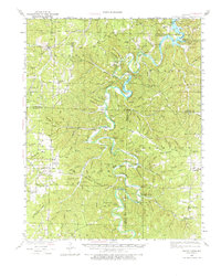
1934 Map of Macks Creek
USGS Topo · Published 1976About this map
The Niangua River winds through this central Missouri landscape, where the 1930s rural economy is defined by isolated settlements and a dense network of country schools. This survey captures a specific moment of transition as the Lake of the Ozarks reaches into the northeast, framing landmarks like Ha Ha Tonka Castle and River Cave Hollow. The terrain is deeply incised by hollows such as Bannister Hollow and Turkeypen Hollow, which dictated the placement of early ridgeside communities and schools like Dry Ridge Sch and Hock Ridge Sch. To the south, the settlement of Leadmine and the nearby Kirk Chapel represent the enduring social nodes of the Ozark highlands. The presence of the Tunnel Dam and the Mozark Club suggests the early 20th-century development of the river for both power and recreation.
Find a feature on this map
142 named features on this map. Tap any name to fly to it.
Don’t see what you’re looking for? This feature index may not catch every label — zoom into the map to look around manually.
Map Details
Editions of this 1934 Macks Creek Map
4 editions found
Other maps of this area

1884 · Bolivar
USGS Topo · 1:125,000

1887 · Warsaw
USGS Topo · 1:125,000

1888 · Versailles
USGS Topo · 1:125,000

1892 · Bolivar
USGS Topo · 1:125,000

1893 · Versailles
USGS Topo · 1:125,000

1894 · Warsaw
USGS Topo · 1:125,000

1932 · Versailles No 4
USGS Topo · 1:48,000

1933 · Stoutland
USGS Topo · 1:62,500

1934 · Macks Creek
USGS Topo · 1:48,000

1934 · Camdenton
USGS Topo · 1:24,000