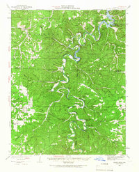
1934 Map of Macks Creek
USGS Topo · Published 1966About this map
The Niangua River snakes through the Ozark Plateau in this mid-1930s survey, illustrating a landscape defined by dramatic bends and deep hollows. The northern reaches show the early influence of the Lake of the Ozarks, with water backing into the narrow valleys near the Ha Ha Tonka Castle and Red Sink. Local infrastructure is anchored by the Tunnel Dam, which utilizes the river's horseshoe bends for power generation.
Find a feature on this map
142 named features on this map. Tap any name to fly to it.
Don’t see what you’re looking for? This feature index may not catch every label — zoom into the map to look around manually.
Map Details
Editions of this 1934 Macks Creek Map
4 editions found
Other maps of this area

1884 · Bolivar
USGS Topo · 1:125,000

1887 · Warsaw
USGS Topo · 1:125,000

1888 · Versailles
USGS Topo · 1:125,000

1892 · Bolivar
USGS Topo · 1:125,000

1893 · Versailles
USGS Topo · 1:125,000

1894 · Warsaw
USGS Topo · 1:125,000

1932 · Versailles No 4
USGS Topo · 1:48,000

1933 · Stoutland
USGS Topo · 1:62,500

1934 · Macks Creek
USGS Topo · 1:48,000

1934 · Camdenton
USGS Topo · 1:24,000