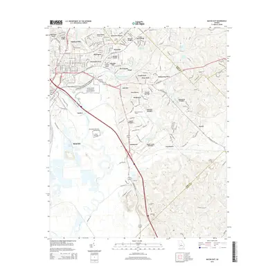
2014 Map of Macon East
USGS Topo · Published 2014About this map
Ocmulgee National Monument and the ancient earthworks of the Lamar Mounds dominate the central landscape of this Bibb County survey, highlighting the deep indigenous history along the banks of the Ocmulgee River. The urban footprint of Macon transitions into dense residential developments like East Macon, Duresville, and Groveland. This 2014 mapping reveals how modern infrastructure, such as the Macon Downtown Airport, integrates with the region's historical geography. Local cemeteries like Stone Creek Cem and Mtn Springs Cem serve as vital landmarks for genealogists, while smaller named settlements including Franklinton and Smithsonia indicate the continued rural-suburban character of the area east of the city center.
Find a feature on this map
63 named features on this map. Tap any name to fly to it.
Don’t see what you’re looking for? This feature index may not catch every label — zoom into the map to look around manually.
Map Details
Editions of this 2014 Macon East Map
This is the sole edition of this map. No revisions or reprints were ever made.
Other maps of this area

1956 · Gordon
USGS Topo · 1:62,500

1956 · Warner Robins
USGS Topo · 1:62,500

1956 · Jeffersonville
USGS Topo · 1:62,500

1956 · Macon West
USGS Topo · 1:24,000

1956 · Macon East
USGS Topo · 1:24,000

1956 · Macon
USGS Topo · 1:62,500

1957 · Macon
USGS Topo · 1:250,000

1958 · Macon
USGS Topo · 1:250,000

1964 · Macon
USGS Topo · 1:250,000
1973 · Macon NE
USGS Topo · 1:24,000