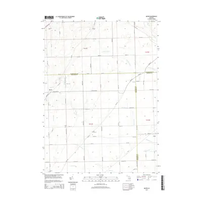
2014 Map of Macon
USGS Topo · Published 2014About this map
The agrarian landscape of Macon and Cone dominates this 2014 survey, where the borders of Washtenaw, Lenawee, and Monroe counties converge. This region of southeast Michigan is defined by its meticulous road grid and the winding paths of Macon Cr and the Saline River. Genealogists will find a high density of rural burial grounds, including Benton Cem, Oakhill Cem, and Lake Ridge Cem, which serve as landmarks among the vast farm plots. The drainage of the land is carefully mapped through features like Schreeder Brook, Bear Swamp Cr, and the Richardson Drain, illustrating the hydrological management necessary for this productive agricultural belt. From the northern reaches near W Michigan Ave to the southern edge by Ridgeway Cem, the map documents a stable rural community characterized by long-standing township boundaries and a network of arterial highways such as Britton Hwy and Ridge Hwy.
Find a feature on this map
66 named features on this map. Tap any name to fly to it.
Don’t see what you’re looking for? This feature index may not catch every label — zoom into the map to look around manually.
Map Details
Editions of this 2014 Macon Map
This is the sole edition of this map. No revisions or reprints were ever made.
Other maps of this area

1902 · Ypsilanti
USGS Topo · 1:62,500

1904 · Ann Arbor
USGS Topo · 1:125,000

1906 · Ypsilanti
USGS Topo · 1:62,500

1906 · Saline
USGS Topo · 1:62,500

1908 · Ann Arbor
USGS Topo · 1:125,000

1912 · Dundee
USGS Topo · 1:62,500

1926 · Dundee
USGS Topo · 1:62,500

1939 · Blissfield
USGS Topo · 1:62,500
1939 · Dundee
USGS Topo · 1:62,500
1940 · Dundee
USGS Topo · 1:62,500