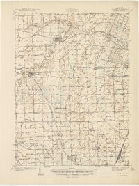
1940 Map of Dundee
USGS Topo · Published 1940About this map
The Raisin River winds through the northern landscape of Monroe County, anchoring the commercial hubs of Dundee and Petersburg. This 1940 survey reveals a dense network of early rural infrastructure, where nearly every township section is served by its own schoolhouse, including Macon Sch, Egypt Sch, and the Stony Ridge Sch. The era's transportation is defined by a heavy concentration of rail lines, with the Ann Arbor RR, Wabash RR, and New York Central RR crisscrossing the terrain to connect small rural sidings and larger junctions. Toward the south, Temperance and Lambertville show early development patterns just north of the state line. A distinctive geological feature, the Big Sink, appears near the Tenmile Creek Valley, illustrating the unique karst drainage patterns of the region. Local genealogy is well-supported by numerous burial grounds like Barber Cem and the Summerfield Cem.
Find a feature on this map
156 named features on this map. Tap any name to fly to it.
Don’t see what you’re looking for? This feature index may not catch every label — zoom into the map to look around manually.
Map Details
Editions of this 1940 Dundee Map
This is the sole edition of this map. No revisions or reprints were ever made.
Other maps of this area

1900 · Maumee Bay
USGS Topo · 1:62,500

1900 · Toledo
USGS Topo · 1:62,500

1902 · Ypsilanti
USGS Topo · 1:62,500

1904 · Ann Arbor
USGS Topo · 1:125,000

1906 · Ypsilanti
USGS Topo · 1:62,500

1906 · Saline
USGS Topo · 1:62,500

1906 · Romulus
USGS Topo · 1:62,500

1908 · Ann Arbor
USGS Topo · 1:125,000

1911 · Swanton
USGS Topo · 1:62,500

1912 · Monroe
USGS Topo · 1:62,500
Featured Places
- Bedford Township, MI
- Lambertville, Bedford Township
- Temperance, Bedford Township
- Raisinville Township, MI
- Ida, Ida Township