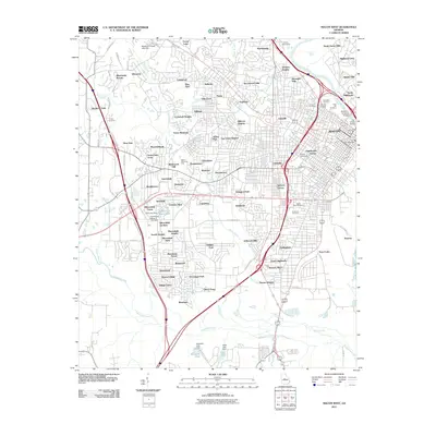
2011 Map of Macon West
USGS Topo · Published 2011About this map
Macon’s westward expansion is heavily documented in this 2011 survey, showing the established neighborhoods and infrastructure of Bibb County. The Ocmulgee River serves as the primary eastern boundary, crossed by the William L Stribling Bridge and Carl Vinson Bridge. Near the river, a concentration of historic grounds including Riverside Cemetery, Rose Hill Cemetery, and Oakridge Cemetery provides a significant touchstone for genealogical research.
Find a feature on this map
119 named features on this map. Tap any name to fly to it.
Don’t see what you’re looking for? This feature index may not catch every label — zoom into the map to look around manually.
Map Details
Editions of this 2011 Macon West Map
This is the sole edition of this map. No revisions or reprints were ever made.
Other maps of this area

1956 · Fort Valley
USGS Topo · 1:62,500

1956 · Bolingbroke
USGS Topo · 1:62,500

1956 · Warner Robins
USGS Topo · 1:62,500

1956 · Macon West
USGS Topo · 1:24,000

1956 · Macon East
USGS Topo · 1:24,000

1956 · Macon
USGS Topo · 1:62,500

1957 · Macon
USGS Topo · 1:250,000

1958 · Macon
USGS Topo · 1:250,000

1964 · Macon
USGS Topo · 1:250,000
1973 · Macon NE
USGS Topo · 1:24,000