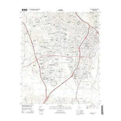
2014 Map of Macon West
USGS Topo · Published 2014About this map
The city of Macon and its sprawling western suburbs are documented in this 2014 survey, highlighting a landscape defined by significant educational institutions and historic burial grounds. The Ocmulgee River curves through the northeast, spanned by the William L Stribling Bridge, while the Central of Georgia railroad lines indicate the area's long-standing industrial importance. The map reveals a dense network of neighborhoods including Unionville, Bellevue, and Payne, alongside prominent academic campuses such as Wesleyan Coll, Mercer Univ, and Macon State Coll.
Find a feature on this map
104 named features on this map. Tap any name to fly to it.
Don’t see what you’re looking for? This feature index may not catch every label — zoom into the map to look around manually.
Map Details
Editions of this 2014 Macon West Map
This is the sole edition of this map. No revisions or reprints were ever made.
Other maps of this area

1956 · Fort Valley
USGS Topo · 1:62,500

1956 · Bolingbroke
USGS Topo · 1:62,500

1956 · Warner Robins
USGS Topo · 1:62,500

1956 · Macon West
USGS Topo · 1:24,000

1956 · Macon East
USGS Topo · 1:24,000

1956 · Macon
USGS Topo · 1:62,500

1957 · Macon
USGS Topo · 1:250,000

1958 · Macon
USGS Topo · 1:250,000

1964 · Macon
USGS Topo · 1:250,000
1973 · Macon NE
USGS Topo · 1:24,000