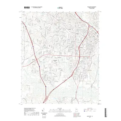
2020 Map of Macon West
USGS Topo · Published 2020About this map
Macon serves as the focal point of this 2020 survey, where the urban landscape of Bibb County meets the winding Ocmulgee River. The map details the historic residential and institutional fabric of the city, highlighting established neighborhoods such as Vineville, Ingleside, and Bellevue. Education and civic life are prominent, with the campuses of Wesleyan College and Mercer University anchoring the northern and central sections of the sheet.
Find a feature on this map
384 named features on this map. Tap any name to fly to it.
Don’t see what you’re looking for? This feature index may not catch every label — zoom into the map to look around manually.
Map Details
Editions of this 2020 Macon West Map
This is the sole edition of this map. No revisions or reprints were ever made.
Other maps of this area

1956 · Fort Valley
USGS Topo · 1:62,500

1956 · Bolingbroke
USGS Topo · 1:62,500

1956 · Warner Robins
USGS Topo · 1:62,500

1956 · Macon West
USGS Topo · 1:24,000

1956 · Macon East
USGS Topo · 1:24,000

1956 · Macon
USGS Topo · 1:62,500

1957 · Macon
USGS Topo · 1:250,000

1958 · Macon
USGS Topo · 1:250,000

1964 · Macon
USGS Topo · 1:250,000
1973 · Macon NE
USGS Topo · 1:24,000