
Loading...
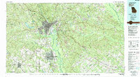
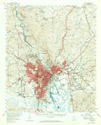
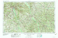
Loading map...1978 Map of Macon
USGS Topo · Published 1980About this map
The Ocmulgee River corridor dominates this central Georgia landscape, anchoring the urban center of Macon and the historic site of the Ocmulgee Nat Mon. By the late 1970s, the region shows a complex intersection of military infrastructure and industrial activity, notably at Robins Air Force Base and the adjacent city of Warner Robins. Further east, the terrain transitions into a resource-rich zone marked by numerous claypits and strip mines near Gordon and McIntyre, following the path of the Central of Georgia railroad.
Find a feature on this map
149 named features on this map. Tap any name to fly to it.
Don’t see what you’re looking for? This feature index may not catch every label — zoom into the map to look around manually.
Map Details
Date Portrayed1978
Date Published1980
PublisherU.S. Geological Survey
Map TypeTopographic
Scale1:100,000
Physical Dimensions43.9 x 24.1 inches
Editions of this 1978 Macon Map
2 editions found
Historical Maps of Macon Through Time
6 maps found


Featured Locations
Source Details
SourceU.S. Geological Survey
CopyrightPublic Domain