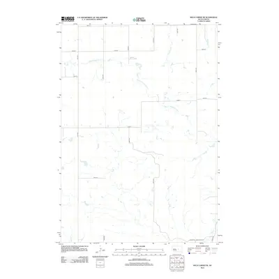
2012 Map of Macs Corner NE
USGS Topo · Published 2012About this map
S Fork Medicine Knoll Cr meanders across this rural section of Hand County, defining the drainage patterns of a landscape marked by numerous small prairie potholes and seasonal wetlands. The map shows a strictly organized grid of agricultural section lines, including 199th St, 344th Ave, and 205th St, reflecting the systematic land division of the Great Plains. In the southern reaches, the terrain shifts slightly as it approaches the headwaters of Elm Cr near the junction of Lawler Rd and Lingscheit Pl. This 2012 survey captures the area’s enduring reliance on a simple network of local roads and state-maintained routes to connect isolated farmsteads and manage the vast grazing and planting acreage of central South Dakota.
Find a feature on this map
17 named features on this map. Tap any name to fly to it.
Don’t see what you’re looking for? This feature index may not catch every label — zoom into the map to look around manually.
Map Details
Editions of this 2012 Macs Corner NE Map
This is the sole edition of this map. No revisions or reprints were ever made.
Other maps of this area

1950 · Highmore
USGS Topo · 1:24,000

1950 · Ree Heights
USGS Topo · 1:24,000

1950 · Highmore SE
USGS Topo · 1:24,000

1953 · Huron
USGS Topo · 1:250,000

1954 · Huron
USGS Topo · 1:250,000

1973 · Macs Corner NE
USGS Topo · 1:24,000

1973 · Miller Dale Colony SW
USGS Topo · 1:24,000

1973 · Macs Corner SE
USGS Topo · 1:24,000
1973 · Miller Dale Colony NW
USGS Topo · 1:24,000

1973 · Macs Corner
USGS Topo · 1:24,000