
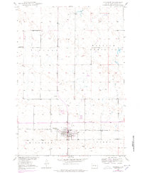
1950 Map of Highmore
USGS Topo · Published 1950About this map
Highmore serves as the central hub of this prairie landscape, mapped during a period of postwar development in the Missouri River Basin. The town is situated along the Chicago and North Western railroad line, which dictates the layout of the region's transport and commerce. Outside the town center, the map reveals an agricultural and educational landscape, featuring the State College Substation and the rural Lincoln Sch to the northwest. The terrain is marked by numerous depressions and small water bodies typical of the glaciated plains, while the presence of the Highmore Airport and several Windmill sites speaks to the infrastructure supporting this Hyde County community. Local genealogy is anchored by the Highmore Cem located just south of the main settlement.
Find a feature on this map
12 named features on this map. Tap any name to fly to it.
Don’t see what you’re looking for? This feature index may not catch every label — zoom into the map to look around manually.
Map Details
Editions of this 1950 Highmore Map
2 editions found
Other maps of this area

1949 · Mitchell Lake
USGS Topo · 1:24,000

1950 · Highmore NE
USGS Topo · 1:24,000

1950 · Mitchell Lake
USGS Topo · 1:24,000

1950 · Highmore SE
USGS Topo · 1:24,000

1953 · Huron
USGS Topo · 1:250,000

1954 · Huron
USGS Topo · 1:250,000

1968 · Holabird
USGS Topo · 1:24,000

1968 · Harrold NE
USGS Topo · 1:24,000

1973 · Macs Corner NE
USGS Topo · 1:24,000

1973 · Chapelle Lake
USGS Topo · 1:24,000