
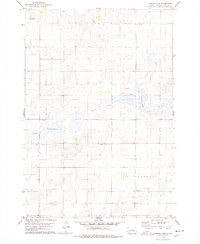
1968 Map of Harrold NE
USGS Topo · Published 1971About this map
Spring Lake and its surrounding prairie depressions dominate this late-1960s landscape in Hyde County. The area is defined by a series of low-lying basins including Spring Lake Valley, Douglas Valley, and Illinois Valley, which likely supported seasonal wetlands or grazing land. While largely rural and sparsely settled, the map shows evidence of local infrastructure like the Valley Sch and scattered Gravel Pits used for road maintenance. This 1968 field check captures the High Plains at a moment when the Missouri River Basin development programs were influencing local land use and resource management. The grid of section lines and township boundaries, including the transition from T. 115 N. to T. 114 N., reveals a highly organized agricultural survey system typical of the Dakotas.
Find a feature on this map
13 named features on this map. Tap any name to fly to it.
Don’t see what you’re looking for? This feature index may not catch every label — zoom into the map to look around manually.
Map Details
Editions of this 1968 Harrold NE Map
This is the sole edition of this map. No revisions or reprints were ever made.
Other maps of this area

1949 · Mitchell Lake
USGS Topo · 1:24,000

1950 · Mitchell Lake
USGS Topo · 1:24,000

1950 · Highmore
USGS Topo · 1:24,000

1951 · Rice Lake
USGS Topo · 1:24,000

1953 · Huron
USGS Topo · 1:250,000

1954 · Huron
USGS Topo · 1:250,000

1968 · Harrold NW
USGS Topo · 1:24,000

1968 · Harrold
USGS Topo · 1:24,000

1968 · Holabird
USGS Topo · 1:24,000
1978 · Thomas Lake
USGS Topo · 1:24,000