
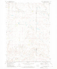
1968 Map of Harrold
USGS Topo · Published 1971About this map
Harrold serves as the primary hub of this central South Dakota landscape, situated along the Chicago and North Western railroad line. The town's grid is small but defined, supported by local infrastructure including the Harrold Municipal Airport to the northwest. For genealogists and local historians, the presence of St John Cem and Medicine Hill Cem south of the tracks provides a vital link to the families who settled this prairie region.
Find a feature on this map
19 named features on this map. Tap any name to fly to it.
Don’t see what you’re looking for? This feature index may not catch every label — zoom into the map to look around manually.
Map Details
Editions of this 1968 Harrold Map
This is the sole edition of this map. No revisions or reprints were ever made.
Other maps of this area

1953 · Huron
USGS Topo · 1:250,000

1954 · Huron
USGS Topo · 1:250,000

1967 · Blunt SE
USGS Topo · 1:24,000

1967 · De Grey NE
USGS Topo · 1:24,000

1967 · Blunt NE
USGS Topo · 1:24,000

1968 · Harrold NW
USGS Topo · 1:24,000

1968 · Holabird
USGS Topo · 1:24,000

1968 · Harrold NE
USGS Topo · 1:24,000

1973 · Chapelle Lake
USGS Topo · 1:24,000
1973 · Chapelle Lake NW
USGS Topo · 1:24,000